Tell that to the 9/11 Commission. You include a graphic that has an
incomplete route, then expect your other arguments to be taken on faith?
The "U" shaped detour on the western route is completely missing. You
can see it on this graphic from USA Today.
Note the dotted line, signifying the route back to the Pentagon when Flight 77
was lost on radar, according to the Official 9/11 Commission Report, starting
on page 24:
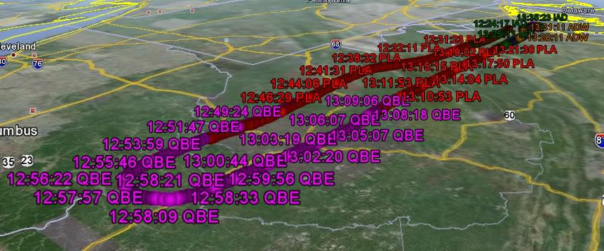
American 77 began deviating from its flight plan at 8:54...Two minutes later, it disappeared completely from radar...Shortly after 9:00, Indianapolis Center started notifying other agencies that American 77 was missing and had possibly crashed...The failure to find a primary radar return for American 77 led us to investigate this issue further....At 9:32, they found one...and at 9:38, seconds after impact, reported to the control tower: "looks like that aircraft crashed into the Pentagon sir."
Flight 77 was lost on radar near Yeager Airport in Charleston WV, with a
runway 6302 feet in length, serving both AA and UA. I am not claiming it
swapped planes there, only that this needs to be checked out.
A new investigation commission needs to figure out why Hani Hanjour made this
strange U turn, exposing him for a longer time to being shot down.
Similarly, why would Muhammed Atta want to expose himself to being shot down
by taking a detour that wasted about 1/2 hour?
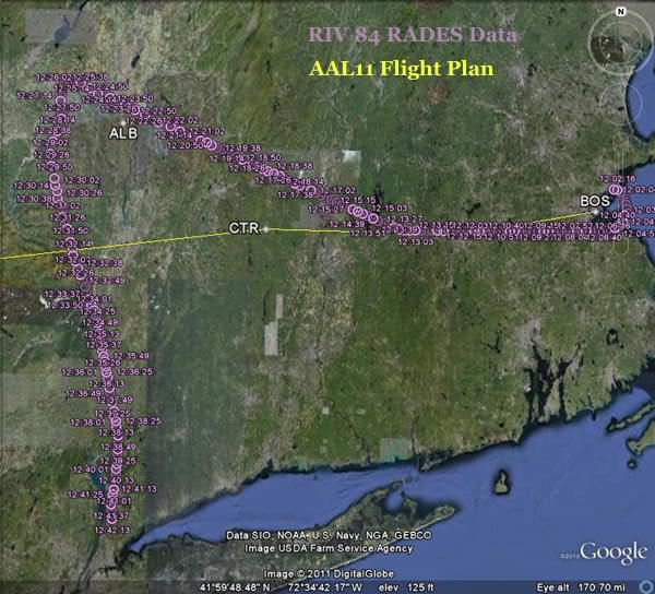
Note that Flight 11 leaves Boston, gets hijacked, then heads straight NORTH
WEST towards Griffiss Air Force Base in Upstate New York. Hey, wrong way
Muhammed! Then Flight 11 turns abruptly south to NYC to crash in to WTC 1.
Dr. Griscom (PhD Brown, Physics, Naval Research Laboratory scientist, chosen
by NASA to analyze Moon rocks, 193 peer reviewed publications) hypothesizes a
plane swap at the northern tip of Atta's Detour. Flight 175 also took a detour
south, near McGuire AFB, then north, when it could have simply hit WTC 2 from
the west.
http://DavidGriscom.com/New911Hypothesis
It is also a strange coincidence that Flight 11 and Flight 175, both taking
off from Boston but 20 minutes apart, crossed paths near Stewart Airport in
down state New York, on their way to hit WTC 1 and 2. The probability of two
planes detouring then intersecting like that by chance is small.
These are strange detours that are clearly visible using publicly available
news data. The hijackers were not the greatest pilots, but they could surely
read a compass, front and center on the plane's dash board. Critical Thinkers
should welcome a New Investigation, if nothing else but to validate the OCT.
This link to a Flash animation shows the routes from all 4 flights on 9/11.
(Still graphic is below.)
http://911Experiments.org/USAToday91...911Flights.swf (Click on "See All
Flights. Go")

This is not true
Thank you for asking so nicely, a good example for JREF. I am up early to
hopefully answer all your questions.
I believe only ONE plane was within a mile of the Pentagon. I am in a
quandary, seeing strong evidence for a North of Citgo approach, but weak
evidence of a Fly Over.
As HAL 9000 said: "I'm sorry Dave. I do not have enough information." That's
why I'm reading JREF, to get more info and challenge my assumptions.
From the evidence I have evaluated so far, there was only 1 plane that
was within a mile of Pentagon - not a 2nd plane, and not a missile.
Because there was only the 1 plane, identified as AA Flight 77 that got
to the Pentagon. If anyone saw a 2nd or 3rd plane farther away from the
Pentagon, it would have been the C130 or the so-called "mystery plane" the
white E-4B mentioned by main stream news plus Discovery.
Although there were 3 in the general area Washington DC, only 1 was
actually close enough to hit the Pentagon. We deserve to see a photo of it,
which probably exists, considering the 85 security cameras the FBI
confiscated.
http://pilotsfor911truth.org/forum/l...hp?t14873.html
No, please don't put me on the Last Responder list. I try to answer as
time permits, and especially not ignore people who ask nicely.
![]()
If people don't respond to us soon it may be:
* Something came up in their personal or work responsibilities
* They didn't like the verbal abuse, and just ignore us
* They are composing and researching a well supported response
* They realize we are right and now agree with us


You are an Air Transport Pilot, so I respect your knowledge about
flights. I posted a link to the news report and graphic made by USA Today, a
main stream news source. Similar descriptions and graphics are found in the
New York Times, Washington Post, etc. So if all these news outlets are
wrong, and you have proof, you are welcome to let them know. You could edit
Wikipedia.
http://en.wikipedia.org/wiki/America...ines_Flight_11
You made a good point that a 20 degree right turn would makes sense go
towards SFO. But, Flight 11 was bound for Los Angeles, not San Francisco.
Now, if I made this mistake you would probably be hounding all over me
"What! Fly much? Clueless! etc." But I'm not like that, and just want facts.
Wikipedia: "The 9/11 Commission estimated that the hijacking began at 8:14."
This is about a minute after ATC instructed them to turn, as you provided.
8:19 Betty Ong reports "The cockpit is not answering..." (Did she not see
any hijackers go in?)
At 8:26:30 Flight 11 makes a 100 degree turn to the south, according to the
NTSB Report, Page 3.
http://www3.ntsb.gov/info/Flight_%20...Study_AA11.pdf
http://en.wikipedia.org/wiki/Timelin...ber_11_attacks
The airplane maintained this altitude and the Northwest heading until about 8:26:30 (point E). At this point, the airplane made a level, left turn to the South.
The continuation of the NORTH west path for 10 to 12 minutes is
suspicious because Atta should have known that NYC is SOUTH west and turned
at 8:14, or at least within a few minutes of the hijacking. He then would
have another 10 minutes or so to get back south. This detour wasted time,
exposing the flight to intercept.
Dr. Griscom hypothesizes that a drone met and replaced Flight 11 near
Amsterdam NY, about 64 miles from Griffiss. It is a common War Game tactic
for 2 or more planes to fly close, to appear as 1 radar blip to the other
side.
Hypothesis means it is a theory, not a claim as fact. It is yet one more
thing for a New Investigation to check out. The OCT is a hypothesis.
You well know this, but here is a graphic for non-pilots to see that the
compass and heading indicator is easy for the pilot to see.